Enter your address in the box below to find out which ward you live in.
The address you have selected is in Ward 1.
Ward 1
Represented by - Jovanka Beckles, Joel Young, and H.E. Christian Peeples
Cities in Ward 1
Albany
Berkeley - The area of Berkeley that is generally north of Cedar Street, west of Oxford Street, south of Dwight Way and west of Telegraph Avenue.
El Cerrito
Richmond
San Pablo
Unincorporated Area in Ward 1
El Sobrante
Kensington
North Richmond
The address you have selected is in Ward 2.
Ward 2
Represented by - Jean Walsh, Joel Young, and H.E. Christian Peeples
Cities in Ward 2
Berkeley - The area of Berkeley that is generally south of Cedar Street and east of Oxford Street, north of Dwight Way and east of Telegraph Avenue.
Emeryville
Oakland - The area of Oakland that is northwest of High Street (between the water and Foothill Blvd.), northwest of 35th Avenue, west of Brookdale Avenue, west of Coolidge Avenue, south of School Street, and north of Champion Street/Lincoln Avenue.
Piedmont
The address you have selected is in Ward 3.
Ward 3
Represented by - Sarah Syed, Joel Young, and H.E. Christian Peeples
Cities in Ward 3
Alameda
Oakland - The area of Oakland that is southeast of High Street (between the water and Foothill Blvd.), southeast of 35th Avenue, east of Brookdale Avenue, east of Coolidge Avenue, north of School Street, and south of Champion Street/Lincoln Avenue.
San Leandro - The entire city of San Leandro except the portion that lies southeast of Fairway Drive/Aladdin Avenue and west of the railroad tracks.
The address you have selected is in Ward 4.
Ward 4
Represented by - Murphy McCalley, Joel Young. and H.E. Christian Peeples
Cities in Ward 4
Hayward - The area of Hayward that is generally east of Hesperian Boulevard, north of Highway 92, and east of the Nimitz Freeway.
San Leandro - The area of San Leandro that lies southeast of Fairway Drive/Aladdin Avenue and west of the railroad tracks.
Unincorporated Area in Ward 4
Ashland
Castro Valley
Cherryland
Fairview
San Lorenzo
The address you have selected is in Ward 5.
Ward 5
Represented by - Diane Shaw, Joel Young, and H.E. Christian Peeples
Cities in Ward 5
Fremont
Hayward - The area of Hayward that is generally west of Hesperian Boulevard, south of Highway 92, and west of the Nimitz Freeway.
Newark
The address you have selected is in Ward 1.
Ward 1
Represented by - H.E. Christian Peeples and Joel B. Young.
Cities in Ward 1
Albany
El Cerrito
Richmond
San Pablo
Unincorporated Area in Ward 1
East Richmond Heights
El Sobrante
Kensington
North Richmond
Rollingwood
The address you have selected is in Ward 2.
Ward 2
Represented by - Jean Walsh and Joel B. Young.
Cities in Ward 2
Berkeley
Emeryville
Portion of Oakland
The address you have selected is in Ward 3.
Ward 3
Represented by - Sarah Syed and Joel B. Young.
Cities in Ward 3
Alameda
Oakland - The area of Oakland that is southeast of High Street (between the water and Foothill Blvd.), southeast of 35th Avenue, east of Brookdale Avenue, east of Coolidge Avenue, north of School Street, and south of Champion Street/Lincoln Avenue.
San Leandro - The entire city of San Leandro except the portion that lies southeast of Fairway Drive/Aladdin Avenue and west of the railroad tracks.
The address you have selected is in Ward 4.
Ward 4
Represented by - Murphy McCalley and Joel B. Young.
Cities in Ward 4
Hayward - The area of Hayward that is generally east of Hesperian Boulevard, north of Highway 92, and east of the Nimitz Freeway.
San Leandro - The area of San Leandro that lies southeast of Fairway Drive/Aladdin Avenue and west of the railroad tracks.
Unincorporated Area in Ward 4
Ashland
Castro Valley
Cherryland
Fairview
San Lorenzo
*Portion of Ward 4 in Hayward represented on the map in light blue is shared with the new Ward 6.
The address you have selected is in Ward 5.
Ward 5
Represented by - Diane Shaw and Joel B. Young.
Cities in Ward 5
Fremont
Newark
Portion of Hayward
*Portion of Ward 5 overlaps with the new Ward 6
The address you have selected is in Ward 6/5.
Ward 6 / 5
Represented by - Anthony C. Silva and Joel B. Young. A portion of Ward 6 overlaps with Ward 5 in the cities of Hayward, Fremont and Newark represented by Diane Shaw.
Cities in Ward 6
Newark
Hayward
Portion of Fremont
Unincorporated Area in Ward 6
Fairview
*Portion of Ward 6 in Hayward represented on the map in light blue is shared with Ward 5 until the November 2026 election.
The address you have selected is in District-At-Large.
District-At-Large
Represented by - Joel B. Young.
District- No Ward Representativeuntil 2026 Election
Cities in District-At-Large
Piedmont
Portion of Oakland
*This area is represented by AC Transit’s district-at-large but will not be represented in a specific ward until after the 2026 election.
The address you have selected is in Ward 6/4.
Ward 6 / 4
Represented by - Murphy McCalley and Joel B. Young. A portion of Ward 4 overlaps with Ward 6 in the city of Hayward represented by Anthony C. Silva.
* Portion of Hayward overlaps between Ward 4 and Ward 6 until November 2026 election.
The address you have selected is in Ward 1.
Ward 1
Represented by - H.E. Christian Peeples
Cities in Ward 1
Albany
El Cerrito
Richmond
San Pablo
Unincorporated Area in Ward 1
East Richmond Heights
El Sobrante
Kensington
North Richmond
Rollingwood
The address you have selected is in Ward 2.
Ward 2
Represented by - Jean Walsh
Cities in Ward 2
Berkeley
Emeryville
Portion of Oakland
The address you have selected is in Ward 3.
Ward 3
Represented by - To be determined by the November 3, 2026 election.
Cities in Ward 3
Alameda
Portion of Oakland
Piedmont
The address you have selected is in Ward 4.
Ward 4
Represented by - To be determined by the November 3, 2026 election.
Cities in Ward 4
Portion of Oakland
The address you have selected is in Ward 5.
Ward 5
Represented by - To be determined by the November 3, 2026 election.
Cities in Ward 5
Ashland
Castro Valley
Cherryland
San Leandro
San Lorenzo
The address you have selected is in Ward 6.
Ward 6
Represented by - Anthony C. Silva
Cities in Ward 6
Hayward
Newark
Portion of Fremont
Unincorporated Area in Ward 1
Fairview
The address you have selected is in Ward 7.
Ward 7
Represented by - To be determined by the November 3, 2026 election
Cities in Ward 7
Fremont
The address you have selected is not in any of the Wards.
District Ward Information
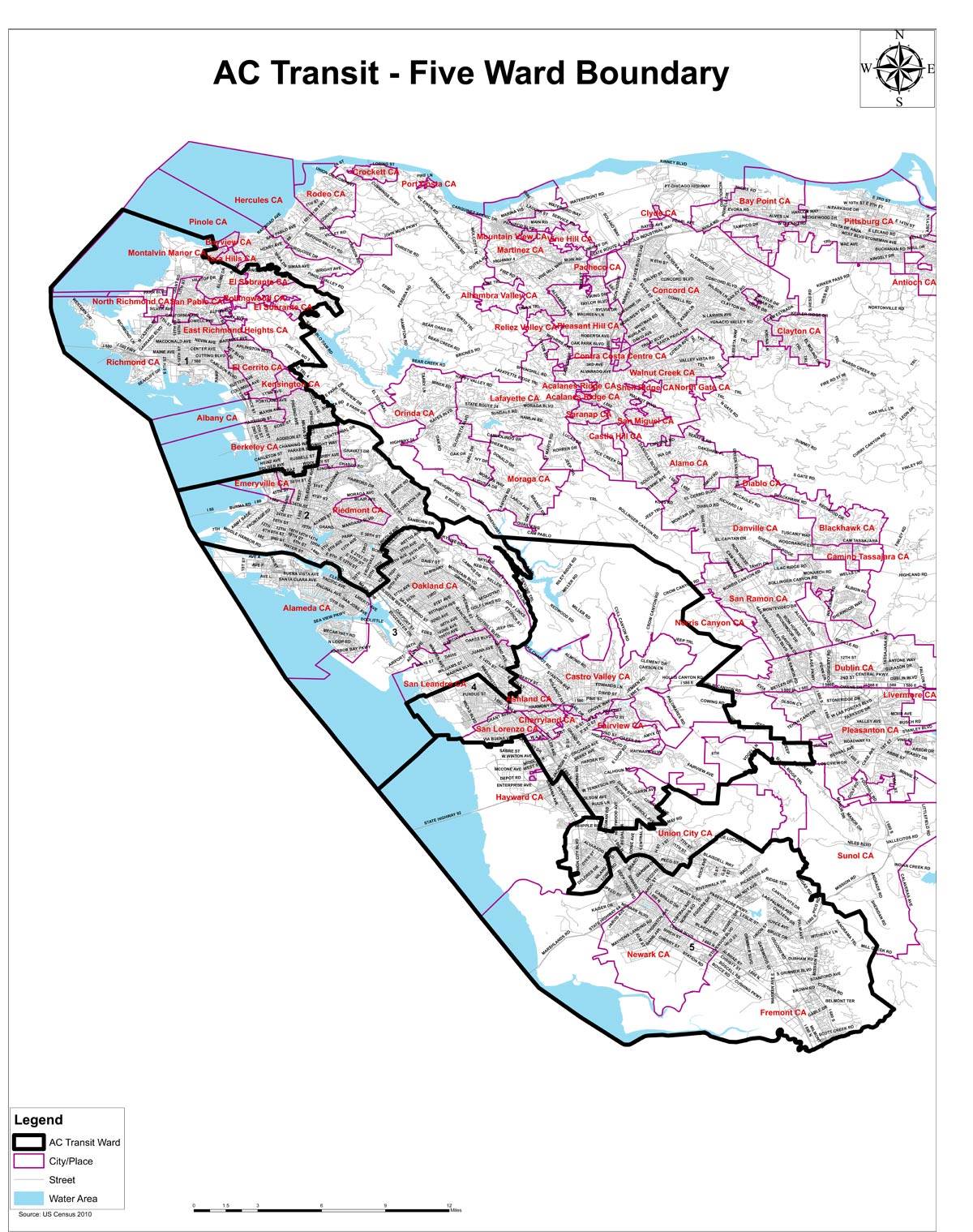
The following is information for district ward map information. It includes individual maps for each of the five districts and statistical population data based on the year 2010 federal census. More detailed information includes a five-ward map, ward statistics, and metes and bounds for each of the five districts.
Click on the Ward in the map on the left to see the detail information about that Ward
Ward 1
Represented by - Jovanka Beckles, Joel Young, and H.E. Christian Peeples
Cities in Ward 1
Albany
Berkeley - The area of Berkeley that is generally north of Cedar Street, west of Oxford Street, south of Dwight Way and west of Telegraph Avenue.
El Cerrito
Richmond
San Pablo
Unincorporated Area in Ward 1
El Sobrante
Kensington
North Richmond
Ward 2
Represented by - Jean Walsh, Joel Young, and H.E. Christian Peeples
Cities in Ward 2
Berkeley - The area of Berkeley that is generally south of Cedar Street and east of Oxford Street, north of Dwight Way and east of Telegraph Avenue.
Emeryville
Oakland - The area of Oakland that is northwest of High Street (between the water and Foothill Blvd.), northwest of 35th Avenue, west of Brookdale Avenue, west of Coolidge Avenue, south of School Street, and north of Champion Street/Lincoln Avenue.
Piedmont
Ward 3
Represented by - Sarah Syed, Joel Young, and H.E. Christian Peeples
Cities in Ward 3
Alameda
Oakland - The area of Oakland that is southeast of High Street (between the water and Foothill Blvd.), southeast of 35th Avenue, east of Brookdale Avenue, east of Coolidge Avenue, north of School Street, and south of Champion Street/Lincoln Avenue.
San Leandro - The entire city of San Leandro except the portion that lies southeast of Fairway Drive/Aladdin Avenue and west of the railroad tracks.
Ward 4
Represented by - Murphy McCalley, Joel Young. and H.E. Christian Peeples
Cities in Ward 4
Hayward - The area of Hayward that is generally east of Hesperian Boulevard, north of Highway 92, and east of the Nimitz Freeway.
San Leandro - The area of San Leandro that lies southeast of Fairway Drive/Aladdin Avenue and west of the railroad tracks.
Unincorporated Area in Ward 4
Ashland
Castro Valley
Cherryland
Fairview
San Lorenzo
Ward 5
Represented by - Diane Shaw, Joel Young, and H.E. Christian Peeples
Cities in Ward 5
Fremont
Hayward - The area of Hayward that is generally west of Hesperian Boulevard, south of Highway 92, and west of the Nimitz Freeway.